
Contains OS data © Crown copyright and database right 2021
Somerset comprises two vice-counties for recording purposes: South Somerset (VC5) and North Somerset (VC6) which are divided (more or less) by the River Parrett, River Ivel (or Yeo) and the A303 trunk road. If you want to find out which VC you are in, enter a grid reference here.
Vice-counties were created by Hewett Cottrell Watson in the mid-19th Century based on the county boundaries at that time. Local government reorganisation has since divided the original county into Somerset, North Somerset, and Bath and North-East Somerset (BaNES) local authority areas. Parts of south Bristol were also originally in Somerset. Some minor boundary changes have also occurred at parish level with small areas of South Devon (VC4), Dorset (VC9), South Wiltshire (VC8) and North Wiltshire (VC7) being included in the modern local authority areas. Similarly, some small areas of VC5 and VC6 now lie within the neighbouring local authority areas.
More recent county floras have used modern administrative boundaries while earlier floras used the original county boundaries. For completeness, Somerset Rare Plants Group makes and holds records for the whole of VC5 and VC6 plus those extra areas now in administrative Somerset.
Members of Somerset Rare Plants Group routinely make records at monad level (i.e., using 1km squares defined by 4-digit grid references e.g., ST4390). More detailed 6- or 8-figure grid references are used for rarer species.VC5 consists of 1838 complete monads and 421 partial ones. VC6 consists of 2085 complete monads and 314 partial ones.
The mapping programme MapMate has been used since the late 1990s by the Somerset VC Recorders to store, analyse and share data, all records being passed on to the Botanical Society of Britain & Ireland (BSBI). Records are also shared with Somerset Environmental Records Centre (for the modern county of Somerset) and Bristol Regional Environmental Records Centre (for North Somerset, BaNES and Bristol). Many historical records have yet to be input. Those collected for the Atlas Flora of Somerset (P.R. Green, I.P. Green and G.A. Crouch, 1997) have been added to MapMate and the BSBI Distribution Database as “skeleton” tetrad spots (with no precise date or recorder details); records made for the Flora of the Bristol Region (I.P Green, R.J. Higgins, C. Kitchen & M.A.R. Kitchen, 2000) are held by Bristol Regional Environmental Records Centre.
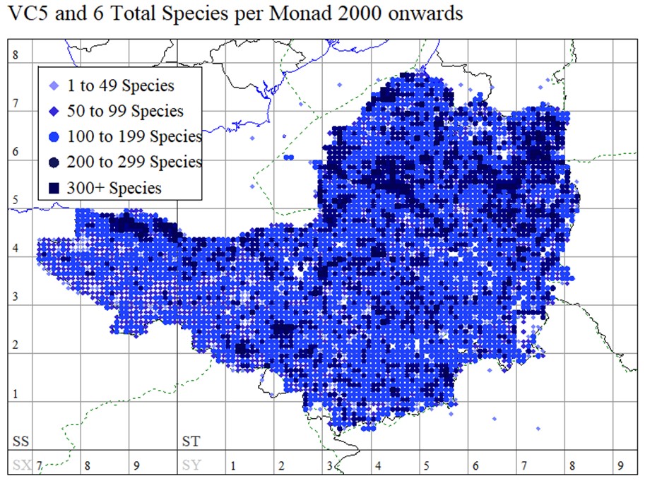
As an aid to inform the recording effort, a simple map of post-2000 species density has been produced using MapMate. An example from 2021 is shown on the left below. More detailed spreadsheets showing coverage per monad since 2000, for both numbers of records and numbers of taxa, are also available. A detail is shown on the right below. These latter coverage maps are available under the Activities>Recording menu. The maps are updated once or twice per year.

